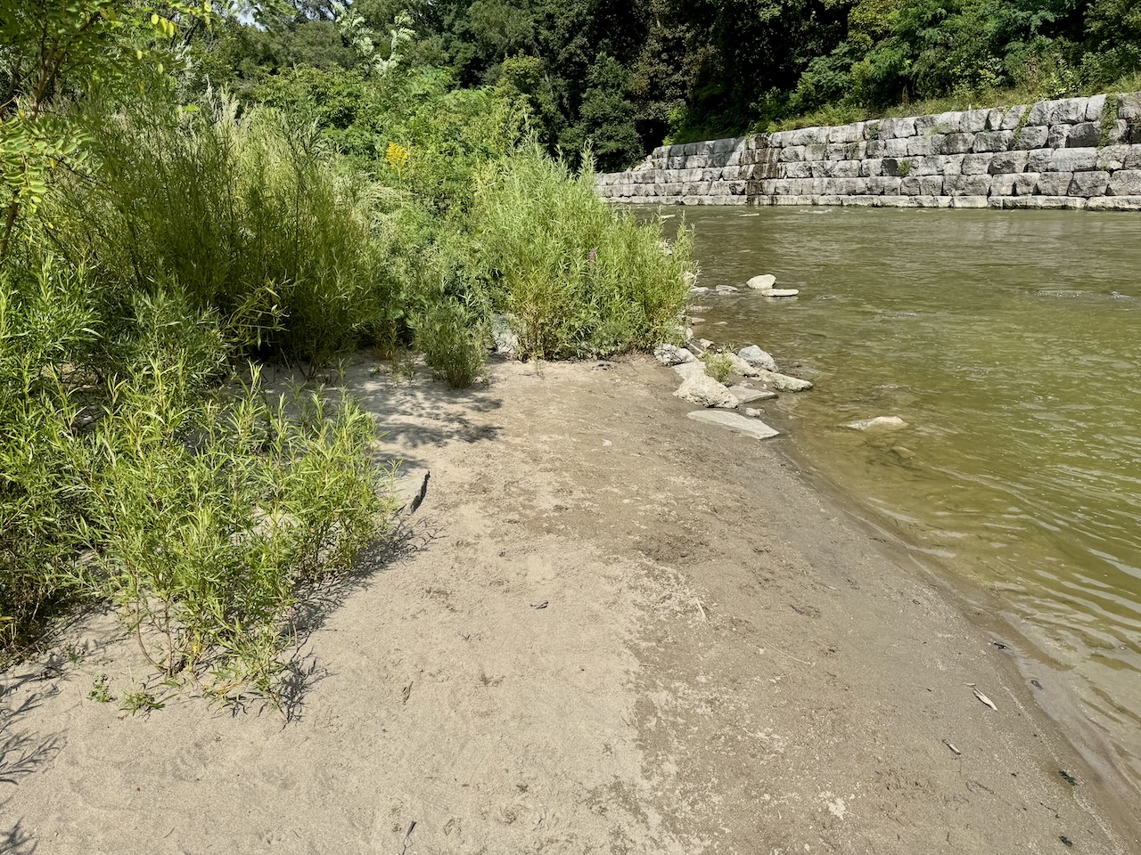
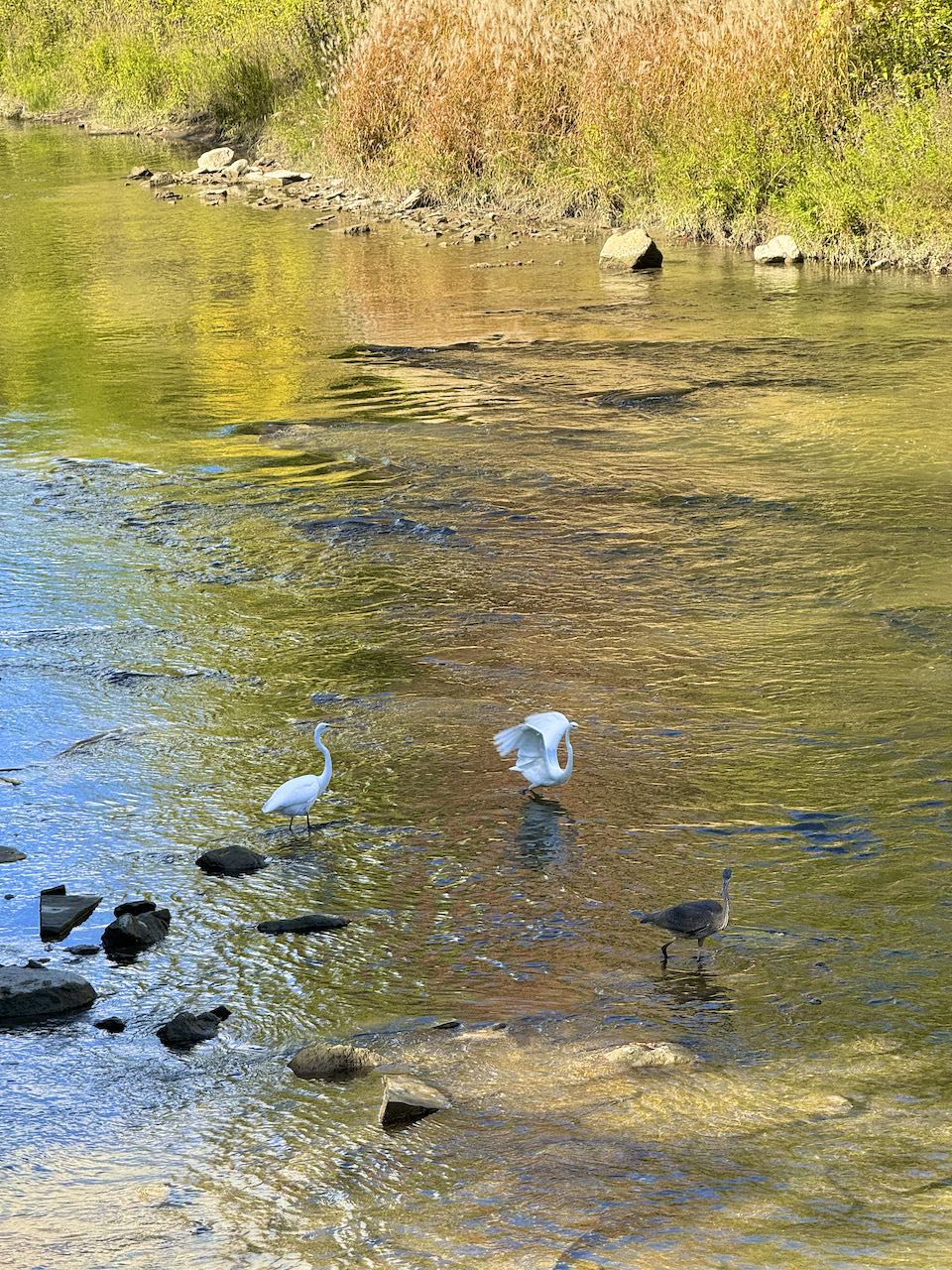
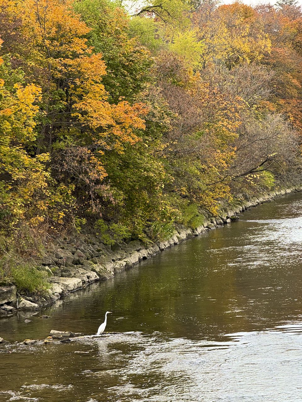
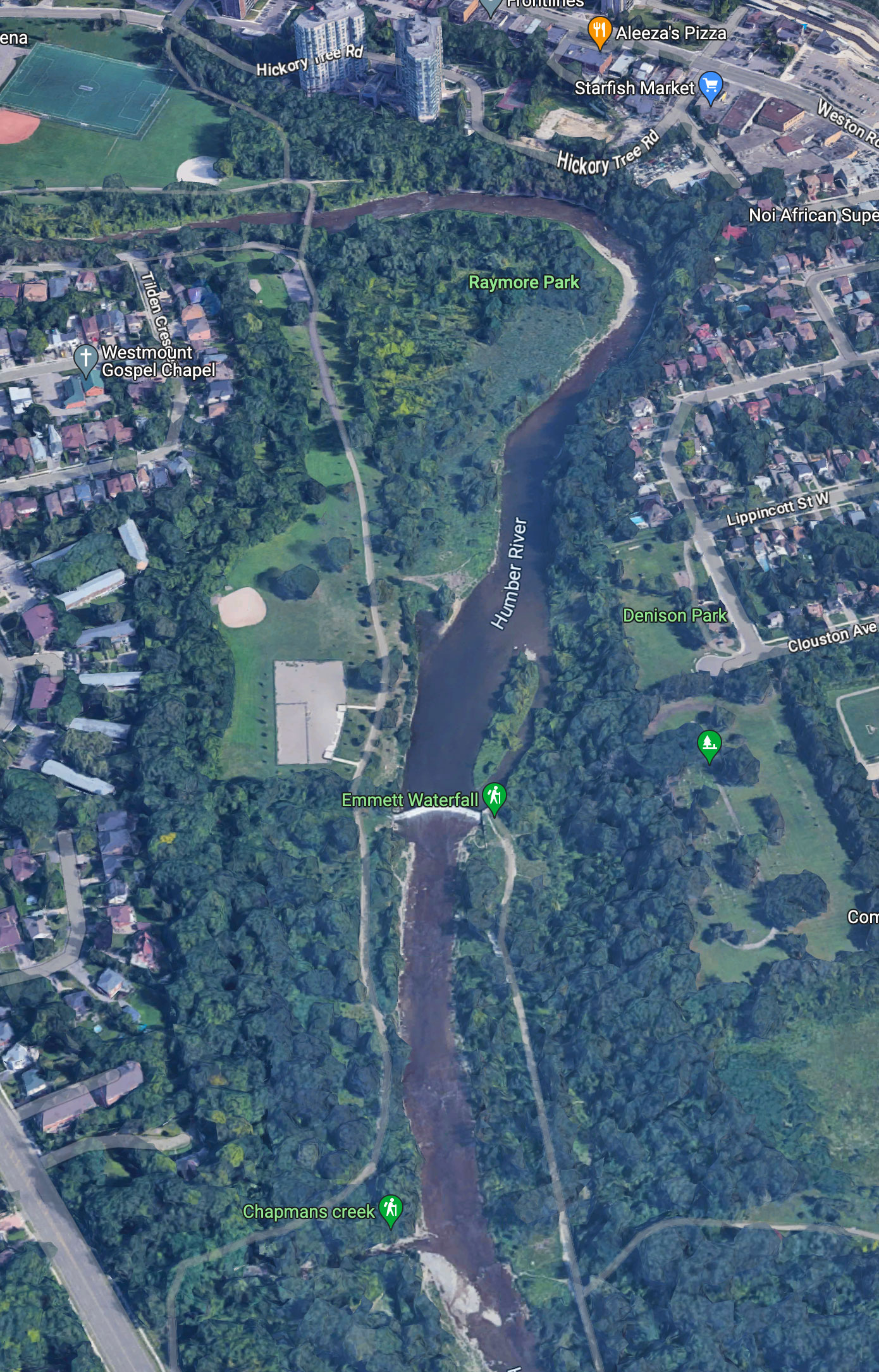
Hazel: 70 years on.

Hurricane Hazel began its trail of devastation as a category 2 hurricane in the Caribbean, killing more than a thousand people in Haiti. It moved northwards hitting the Carolinas as a category 3 thanks to warm waters off Florida. As it passed over land, it weakened to a tropical storm and then became a depression but thanks to a merger with a cold front, Hazel was re-energized and the resulting system started dumping water on the GTA on the 15th and 16th of October 1954.

High pressure pushed Hazel over Toronto where it combined with a low-pressure area and cold front.

Local historian Madeleine McDowell correctly points out that the Humber River has the sharpest drop from source to mouth of any river in North America. As a result, when heavy rains fall, the river becomes fills up quickly. Events similar to Hazel have occurred in the past. In fact, in the 19th Century, Weston was moved to the east bank of the Humber after several catastrophic floods. Weston Golf and Country Club now occupies the site of the old settlement.

Raymore Park was one of many created after Hazel as part of an effort to clear flood plain lands and give rivers space where excess water can be absorbed.

Read more about Hazel’s legacy here.

The old location of Raymore Drive. Present day Tilden Crescent begins below the square in the top left. Gilhaven Avenue (running from bottom left) is now occupied by Raymore Park’s parking lot.

Topologically, the Humber catchment area is relatively unchanged since the glaciers left about ten thousand years ago. The valleys are the same width, and the drainage area is the same. Rare events like Hazel will continue to happen. The problem is that since 1954, a good portion of the Humber watershed has been paved over.

Click to enlarge.

In 2002, urban land occupied 20.7% of the watershed. By 2020 that amount was 26.7%, a significant increase. Natural cover is also decreasing although forest canopy is relatively stable at 29%. Because there is less land and vegetation to absorb rainfall, water enters the Humber faster causing river levels to rise quicker and higher than in the past. In addition runoff from paved land is dirtier affecting animal habitats and our drinking water. When the next Hazel type storm drenches our area (and it will), the effects may be far more severe.

Q: Is climate change a factor in events such as Hazel?

A: We can speculate, however, urbanization is a far more immediate danger. For example, the proposed Highway 413 is a huge threat to the watersheds of both the Humber and Credit rivers.

Read more here and here.

If you would like to commemorate the 70th anniversary of Hazel, meet in Raymore Park on Sunday October 13 between 1 and 3pm. Historian Madeleine McDowell will be there to talk about the event.

Handicapped Parking comes to Raymore Park.

Two new handicapped spaces have been created.

For years there were no clearly delineated parking spaces in Raymore Park’s parking lot. People just parked, sometimes on the far side of the lot facing the path. The parking lot was repaved in 2019 and voila, a mere five years later, lines have been drawn to mark out two handicapped spaces along with about 14 other designated spots.

Raymore Park’s Beach is back.

Looking north towards the retaining wall.

The Humber makes an almost 90° turn inside Raymore Park and as the current slows down on the inside of the curve, sand is gently deposited on the western bank. When the river level is high, the sand is flushed downstream towards the lake. The sand comes from the Oak Ridges Moraine where it was dumped by glaciers that melted over 12,000 years ago.

The beach in May 2014 from about the same spot showing the old retaining wall.

This is the beach that was used by children from the subdivision destroyed by Hurricane Hazel in October 1954. The beach is a dynamic thing; some years it isn’t much at all; sometimes expanding and sometimes shrinking but the sand will continue to be be deposited for the next several thousand years until there’s none left upstream.

Read more about the beach here and about what washes ashore here.

Make do and mend.

Looking north towards the weir along the Humber Trail in Raymore Park. August 2024.

Crews have finally repaired sinkholes in the bike path south of the Weir. Some of these were decades old, quite deep and particularly dangerous to inattentive cyclists. Often they would fill with water, freeze and a layer of snow would hide the slip hazard.

This section of the trail was newly paved at least 30 years ago.

Read more here.

Infrastructure problems affect Raymore Park

Visitors to Raymore Park may have noticed loud diesel pumps at the entrance and a rubberized pipe crossing the footbridge onto the Weston side.

The neighbourhood around Raymore Park has been experiencing sewage backups thanks to a blocked sanitary sewer at the park entrance. Last month sewage was seen spilling out of a manhole cover and making its way into the Humber before crews could get on the job. This sewer has been blocked before, causing sewage to enter neighbourhood basements.

Raw sewage spilling from a manhole cover and making its way into the Humber. June 18, 2024.

A City work crew came out and discovered that the sewer was blocked on both sides of the river by tree roots and was crushed on the Weston side. After realizing that it was a big job, workers installed a temporary by-pass powered by a diesel pump. Sewage is now being piped over the pedestrian footbridge and into the sewage system.

Sewage piped over the bridge towards the main sewer on the Weston side. June 24, 2024.

The job of clearing, repairing and relining the underground sewers is being put out to tender – a process that will take weeks if not months. Unfortunately, diesel pumps sometimes fail (twice in the last month) and these breakdowns have led to basement back-flow valves activating and in some cases, flooded basements – this is especially true during rain.

A backflow valve for basement installation. http://backwatervalve.com/

Until the sewer is cleared, repaired and relined, the bypass will carry neighbourhood sewage over to Weston. Let’s hope that the diesel pump will be carefully monitored so that local residents don’t have to deal with further sewage back ups and flooded basements.

Huge rainfall swells Humber.

The Humber at rare levels.

July 16, 2024 was a rare but not unexpectedly rainy day. July often sees huge dumps of rain and Toronto received around 10cm in quite a short time. The Humber has a tell-tale depth gauge in the form of the old footbridge abutment which yesterday completely disappeared.

By way of comparison, here’s how it looked in April 2022.

The old footbridge abutment is clearly visible on most days. April 24, 2022.

As the city grows and more land is paved over, the ability of the river to hold huge volumes of runoff will be tested. Without green spaces and parkland to absorb runoff, the Humber would be much more of a threat during heavy rain or spring thaws.

Signs of Fall

Fall looks as if it’s here to stay as temperatures are set to lower sharply next week. The first dip below zero of the season is forecast for October 30 which is slightly earlier than Toronto’s average of November 1-10.

Here are some recent images of the park as it eases into the approaching winter.

Colourful Boston ivy decorates the Humber footbridge entrance. October 2.
Sumac beginning to turn colour by the park entrance. October 2.
Two egrets and a blue heron. The egret (centre) was just about to chase the heron away. (October 12)
A lone egret with fall colours in the background. (October 24)
Norway Maple foliage is more colourful this year. October 28.

Today in Raymore Park

A worker feeds branches of an elderly Norway Maple into a wood chipper.

A large Norway Maple by the parking lot is coming closer to the end of its life. The tree provides much needed shade but its days appear to be numbered as more rotten branches are found. It is the last of several large maples that once lined (and shaded) the parking lot.

Off-Leash Area, six years later.

The Raymore Park dog off-leash area (DOLA) was opened with some fanfare by Premier Doug Ford’s nephew six years ago. Its design followed standard Toronto Parks and Forestry protocols, namely removal of vegetation and topsoil then replacement with pea-gravel and fenced with rustic poles and rails backed up by a wire containment fence. The aim was to provide an off-leash area where dogs could exercise and socialize safely. The idea, sold at a community presentation was that the DOLA would be used mainly by local residents and that any extra traffic would be minimal.

The site of the present-day DOLA back in October 2008 looking south-west..
The DOLA under construction in February 2017 looking north-west.
Then councillor (red top) Mike Ford at the opening ceremony on July 10, 2017.

The DOLA was built with several design flaws.

1. The small dog enclosure is only accessible by passing through the large dog enclosure.

Small dogs must run the gauntlet to get to their enclosure. July 2017.
The small dog area with landscape fabric in the foreground. July 2023.

2. The pea gravel surface irritates dog paws making exercise out of the question for most.

3. No shade for dogs and owners. A few trees have been planted but these will take many years to mature.

Some trees have been planted but no shade – and harsh pea gravel. July 2023.

4. The space is totally alienated from nature and looks more like a cattle feedlot.

The DOLA and remaining (unused) baseball diamond just north of Emmet Waterfall. Google Maps.

A few observations:

  1. The DOLA is empty most of the day.
  2. The DOLA is popular with commercial dog walkers but a majority of individual owners seem to prefer other parts of Raymore park.
  3. Commercial dog walkers are banned from November through May but many of them use the park year-round.
  4. Compared to the rest of the park, the off-leash section is a barren wasteland.
  5. Thanks to pea gravel making running uncomfortable, dogs get little exercise.
  6. Many people ignore leash by-laws in the park.
  7. The DOLA has done little to protect park wildlife from off-leash dogs.
  8. By-law enforcement seems to have disappeared since Covid.
  9. The DOLA seems to have been a huge waste of money and resources.

Overall Grade: D-

Public Consultation:

A Toronto-wide consultation process was begun in June 2019 to gather feedback on how to improve DOLA design with stakeholder meetings and public surveys. The effort seems to have ground to a halt during Covid as there are no updates beyond this one in 2020.

My two cents: The DOLA should never have been built as there was no demand for it – especially for one so flawed. Far better, cheaper and less disruptive, to have allowed the huge open space between the two unused baseball diamonds to be planted with native trees and create a woodland / wildlife corridor that would join with the one south of the weir.

What might have been – extending the woods north beyond the falls to form a wildlife corridor. Google Maps.

Extra Credit: Read Maria Kwok’s thorough review of Raymore Park’s DOLA here.

Bike Path in bad shape.

Back when Mugsey was alive, I was walking with a fellow dog-walking friend when she slipped on ice that had formed in a bike path depression south of the weir. A thin layer of snow had concealed the ice lurking beneath and down she went, breaking an arm.

This was around 2011. The depression is still there along with several others. Some of them are quite deep and could cause a serious accident if a cyclist was caught unawares.

This one is filled with mud. July 2023.

The bike path is in need of levelling and repaving to today’s standards but for some reason, it’s not been a priority.

The photo doesn’t do the depth of the depression justice. June 2023.

Someone has helpfully used spray paint to outline the depression (and a few others in the vicinity) but nothing has been done since 2011. Maybe if Toronto is serious about creating a network of bike lanes around our city, these dangerous depressions can either be repaired or the bike path repaved and brought up to standard.